Wednesday, September 12, 2018

Alaska to Colorado: British Columbia to Alberta


The road from Watson Lake to Liard Hot Springs was home to many wood bison.  They were re-introduced to this area in 1986 and, from the looks of things, they are feeling right at home.  We saw lots roaming the highways without a care in the world.  Wood Bison are larger and heavier than Plains Bison and are the largest terrestrial animal in the northern hemisphere.


The Liard River parallels the Alcan from Watson Lake to the hot springs.

Well, this very kind couple came to our rescue as the warning system for
the brake buddy went off.  It turned out that the battery was dead in the CRV.
We stopped along the highway (luckily not much traffic) but couldn't
disconnect safely here by undoing the tow and charging with Maxine,
so we flagged down these people who just happened to have a portable
battery charger.  Hallelujah!  These northerners are prepared for anything!

We camped in a gorgeous forest setting at Liard Hot Springs, which has a
really great rep.  All kinds of Canadian friends told us that we must stop
here.  It did not disappoint.
Liard River Hot Springs is right over the border in BC.  The water here is mainly Calcium Carbonate and the mineral content is 1,000 parts per million.  It makes for some interesting plants which are very spongy.  There are 14 species of orchids that grow here because of the hot springs.


There is a 1/4 mile boardwalk that leaves from the campground to the hot
springs.  It crosses an interesting wetlands environment.  I would have liked
much more time here-not only to enjoy the hot springs more often but to explore
the wetlands which give the area its name as the Liard Tropical Valley.

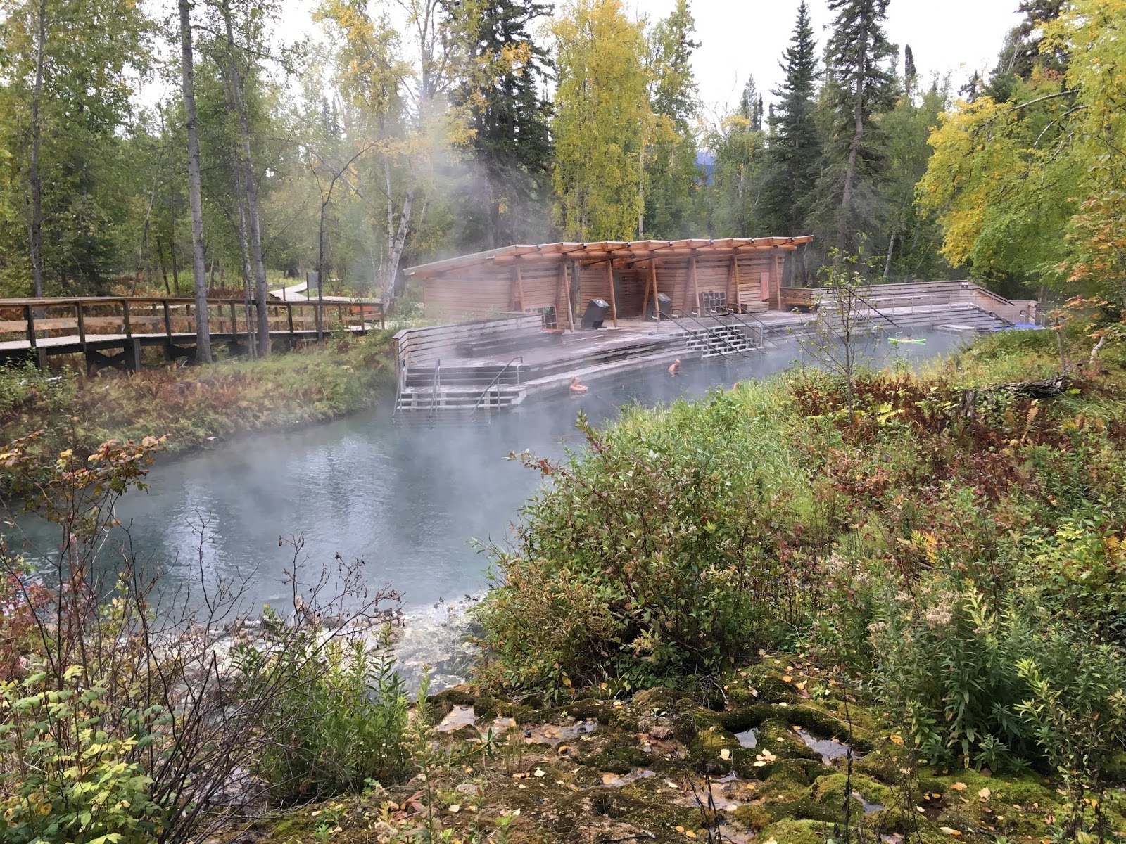
This was just the most gorgeous setting-so natural and unlike many other
hot springs that just feel like warm swimming pools.  I went early in the
morning and loved moving around in the knee deep water looking for the
 hottest spots.

This became my favorite place (credit to Jim for finding it last night).
There was a beautiful cairn built here and I made a small one out of black stones next to it .

The building itself was simple and natural.  Places to change were right
behind these walls.

Look what we saw on the road out later that day!  These reminded us of
the huge bison we had seen in the Badlands of South Dakota many years ago.

More beautiful rivers along the road


Muncho Lake
You can't tell from this picture as it is so cloudy, but it is a beautiful
jade green color.  It is created by tiny rock fragments scraped from the
valley walls by glaciers and carried by meltwater downstream to the lake.
Most of it sinks to the bottom with fine particles suspended in the lake wate,
reflecting and scattering sunlight.

There's that color!

And look who is waiting patiently for me to return from the lake!

The Terminal Range west of the lake


This was quite a remarkable area for wildlife.

Caribou herd on the highway


We had almost given up on ever seeing caribou, especially when we didn't see any on the Top of the World Highway.

They didn't know they weren't supposed to play in the street.

All the adults have antlers-male and female.

And all, especially the youngsters, have the cutest tails!

A herd of Stone Sheep
They are indigenous to the southern Yukon and northern BC.  They are darker
and smaller than the bighorn sheep found in the southern rockies and are often
mistaken for mountain goats.

She blends right in, doesn't she!?
 We had quite an adventure finding a place to camp for the night.  We decided to stop early (though, because we got terribly lost on a wet, muddy and eventually unpassable dirt road, it ended up late).
We were looking for Andy Bailey Lake outside of Ft. Nelson and missed a poorly marked sign.  Luckily (luck has been with us, despite our many challenges on this trip) a man in a four wheel drive stopped us and told us that we were way off the beaten path.  He helped Jim back into a field where he could turn around and, since I was driving the CRV, we both managed to follow him out to the main road and he signalled where the turnoff was.


We finally arrived and found a great spot right on a lake.  We were the
only ones here.

Andy Bailey Lake

Our beautiful fall forest 

And a path that just beckoned us to follow it down
and around the lake.  The only sound was a very
quiet woodpecker.
 In the morning, mist was rising off the lake and we cooked a nice breakfast of bacon and eggs to sustain us for the trip ahead.  We were hoping to visit Jasper, Lake Louise and Banff with Julie and a friend but, because of our NYC trip, we were unable to join them.  Since snow was coming, we decided to b-line it to Edmonton, where our friends, Cheryl and Bill live and try to beat the snow.


Monday, September 10, 2018

Alaska to Colorado: Dawson City to Watson Lake


This part of the Yukon, Northwestern Alaska and Siberia is known as Beringia.  During the Ice Age, glaciers covered much of the northern hemisphere and this is the area formed by melted water at the glacial margin.  Eventually, the sea level dropped making possible the Bering Land Bridge which helped to disperse flora and fauna, as well as humans.  11,000 years ago it was submerged again.


This is the remains of an old roadhouse where stage coaches stopped with
their passengers for a night.  The drivers were called Skinners.  The early
stage drivers faced flooded paths, raging rivers, snow and ice.  Many of the
passengers learned to carry rum with them to keep the drivers happy while
they drove them to their various destinations in this very wild land.

We had a leisurely drive through Carmacks along the Yukon River.  We decided to stop at Lake Laberge, which is formed by a 30 mile section of the Yukon known as a Canadian Heritage River.  It was originally settled by the Athabaskans as it was rich in wildlife.  It eventually became a trading site for the natives who traded their winter furs for fish oils, seaweed and shells from the Tlingits (Pronounced Clingits) from the Pacific Coast.  The campground was very small, with only two sites that had incredible views. We managed to snag one of them.  If the weather had been nicer, we may have stayed a few more days.


We met an interesting man from Kugluktuk who does weather and air traffic control.  I wondered what these people do far north of us!  From Lake Laberge, we headed down the road a short distance to spend a night at the Takhini Hot Springs.  We took turns as Boo was not allowed in, of course.  It was delightfully relaxing.  Boy, we sure do miss our hot tub!


Love this picture of a cold day in the hot springs

We saw these female elk lazing about while a male somewhere was bugling
like crazy!
I woke up to frost everywhere I looked. It was 34 degrees at 9 am.  We drove through gorgeous black spruce forests with red and green fall grasses.  Unfortunately it was pouring rain and freezing and fortunately not much traffic.  We boondocked halfway between Teslin and Watson Lake on the Yukon.  We headed towards Whitehorse, where we had our last halibut and chips of the trip.

This restaurant was originally a mail and freight business.  Before 1921
only first class mail was delivered in winter.  The rest waited here until
the ice broke up and the steamers could sail (usually May).  It closes today
until Mother's Day.  These Yukoners are mighty tough-the winters get
down to 40 below zero!
Next we visited the Kwanlin Dun Cultural Center. Here, there are exhibits which explore the lives and experiences of native peoples of the Yukon.  The Kwanlin Dun have two clans, the Wolf and the Crow, as shown by the art work at the entrance and throughout the art work inside.


There was a large canoe in the entrance and these paddles
which were the result of a project called the healing
canoe.  The purpose was to reconnect young adults to their
culture.  A local man took 19 kids who were struggling with
various addictions to an island near Lake Laberge to create
the canoe and paddles which took 10 weeks.  Half the
participants are addiction-free today.

This was a commissioned piece of art which represents
the incomplete lives of women who have gone missing
or murdered.  It is meant to celebrate Indigenous
female resiliency.
We spent some time in Whitehorse, dumping, getting water, propane, groceries and wine.  We took off hoping to stop for gifts at George Johnson but it closed at five sharp, as did the cultural center in Teslin.  We arrived at 5:05!  Oh, well-saved some moolah!  The drive was again astonishingly beautiful, despite the rainy, cloudy weather.


We continued down toward British Columbia, crossing the Continental Divide along the Rancheria River.  We felt so sorry that we had to push on as there were so many gorgeous spots we would have liked to stay along this section of the Alcan.

As early as 1930 President Hoover was considering an overland route to Alaska from the lower 48.  When the Pearl Harbor bombing took place in 1941, the construction of the highway became a military necessity as a supply road to defend North America against the Japanese.  Amazingly, the road was completed eight months after construction began in March of 1942.  More than 11,000 American troops including 7 regiments of engineers and 16,000 civilian workmen were involved.  It was a herculean task of penetrating 1500 miles of mountains, muskeg and mosquitoes.  It was a difficult, painstaking life for all involved.  Fatigue, hypothermia and accidents plaqued the workers.  They set down eight miles of road a day, seven days a week.  Road conditions at first were horrific:  90 degree turns, washouts, drainage problems and 25% grades and  it was little more than a rough trail. Today, the road is pretty amazing, if flawed.  There are problems with permafrost which makes the road heave in places;  there are virtually no services until you hit the very few major towns and there are potholes everywhere.  We were surprised that there were hardly any road crews working on the roads, though there are plenty of gravelly areas where they have been.
 Some memorabilia of the Alcan Highway in Watson Lake:


The biggest disappointment of the trip (besides not seeing Denali) was that the Northern Lights Centre was closed on weekends.  However, we stopped at the Sign Post Forest in Watson Lake where travelers have left more than 85,000 signs to the collection.  It is now a Yukon historic site.